

How Photos From Old Spy Satellites Are Helping To Find Ancient Ruins Today
James Bond, space tech, and archeology are forming an interesting partnership


No one does irony better than history. About forty-five hundred years ago, ancient Egyptians looked at heavenly bodies to align pyramids to the north. The satellites or stars in the sky proved ideal markers.
Kate Spence, an Egyptologist from the University of Cambridge, explains that people with limited technology could use simple methods to do this. All you needed was a plumb line or a weight hanging at the rope's end.
She tells the BBC two stars circle the North Pole, Kochab and Mizar. The Egyptians called them “the indestructibles” because they were always visible in the night sky. An early astronomer could just set up the plumb line and wait until the two stars rotated into a position where they intersected the device.
She says, “The sight line to the horizon would aim directly north.” Although this method lost accuracy over time due to Earth’s wobble, it was relatively close for a civilization without advanced technology. Now, here’s where the irony comes in; today we’re going in reverse.
While the Egyptians used heavenly bodies to build structures, we use them to discover ruins. But our stars of choice are man-made creations and — in another bout of irony — were created for a much different purpose.
Between 1960 and 1972, the United States launched a series of spy satellites code-named CORONA, which took about eight hundred thousand pictures across the Earth. In 1995, these photos were declassified.
Afterwards, archeologists tired of blindly stomping through inhospitable terrain realized they could use these photos to identify ruins from space. It revolutionized the discipline in many ways, creating what is now known as space archeology.
But let’s take a step back first. Before we can search for ruins on Earth, we need to understand CORONA itself.
Cold War Cutting Edge Spy Tech
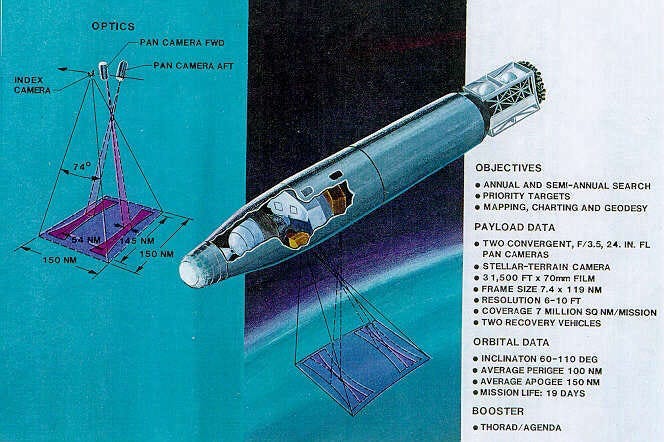
“The program’s goals were daunting: launch a large camera into earth orbit, photograph specific points and areas on the earth’s surface, parachute a capsule of exposed film to earth, snag the capsule in midair over the Pacific Ocean, develop the film, and search the images for answers to the nation’s pressing intelligence questions. Many things could go wrong–and did.”
As the Cold War was underway between the United States and Soviet Union, intelligence became a major issue. Mainly due to the USSR’s lockdown of its territories. The West needed a way to monitor the Soviet development of nuclear weapons and armaments in general.
U2 spy planes became a temporary stopgap, but from the very beginning, they were picked up by radar. After the Soviets shot a plane down, another method was needed. Space became the obvious alternative.
The CORONA program was undertaken to deploy a satellite into orbit with cameras but had a rocky start. According to the CIA, the first thirteen attempts failed. However, the fourteenth successfully returned pictures to Earth, and captured more data than all the U2 flights combined.
The program itself was so crazy for the time, it could have been the plot for an over-the-top James Bond spy flick.
According to Archeologist Jesse Casana's article in The Journal of Field Archeology, the later satellites had dual cameras providing stereo imagery of nine and six-foot resolution. In other words, it became “possible to…view the landscape in 3D.”

The cameras were also designed to get wide panoramic views of large areas to detail structures on the ground.
The CIA explains that after pictures were taken, the film was transferred to a bucket, which was ejected from the satellite and dropped to Earth. This capsule deployed a parachute on the way down. As it fell, a navy plane with a hook on the back retrieved the package.
Over the twelve years of operation, these satellites captured over seven million square miles of pictures. Oddly, all the characteristics that proved desirable for a spy agency also worked wonders for archeology. And these pictures are still valuable today.
Why The CORONA Images Are Still Important For Archeology
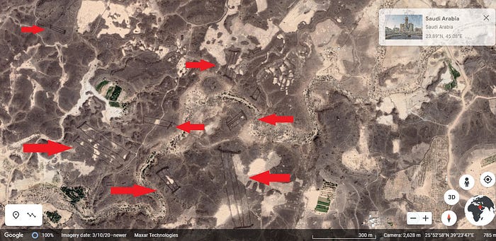
The picture above is from Google Earth. It displays rectangular Neolithic monuments called “Mustatil” built in Saudi Arabia about six thousand years ago. I researched and pulled this image myself from the comfort of my laptop. So, you might be asking why we need photos from 1960s-era satellites.
After all, modern tech must eclipse things available from when the Beach Boys were topping the Pop 40 music charts. Right? Well, yes and no.
Casana reveals that a unique benefit of CORONA pictures is the timeline they were taken in. They’re a view almost sixty years into the past. When many of these pictures were taken, much land hadn’t been developed yet. So, some areas are now flooded or built on, which cover evidence of ancient structures.

As previously mentioned, stereo photos also add the ability for modern computers to make dual pictures three-dimensional. Add to that the sheer volume of the images from across the globe.
Finally, the time of day the pictures were taken also plays a part, according to Casana:
“CORONA was collected in the late afternoon with the intention of highlighting surface topography, unlike modern satellite imagery which is most often collected at solar noon in order to maximize surface reflectance, such that archaeological sites and features with topographic expression such as mounded settlements, field walls, or earthworks appear more clearly than in modern high-resolution satellite imagery.”
Now, after nerding out on all these spy gadgets, let’s move back to the field of archeology and see what benefits the satellites have provided.
Archeological Finds Aided By CORONA
For starters, Jesse Casana and some colleagues found nearly four hundred unknown Roman forts using satellites. Effectively, his team covered nearly one hundred twenty thousand square miles of the Fertile Crescent without ever leaving an office. However, this isn’t the only find.

Qiushi Zou and his team at the School of History, Wuhan University has discovered over thirty sites near the Yangtze River. Zou says CORONA images have also been used to find a water engineering system from five thousand years ago in Liangzhu, along with archeological sites in England, Syria, Iran, and Egypt.
The Center for Advanced Spatial Technologies (CAST) at the University of Arkansas has created software for correcting distortions from the original photos kept by the US Geological Survey. CAST claims the CORONA images have resulted in discovering eight hundred thirty-three archeological sites.
What’s more, CAST only catalogs a small portion of the photos managed by the US Geological Survey, so there’s much room for growth and new finds. Plus, individual archeologists can use their technology to correct CORONA photos independently. So, this total number of discoveries will increase.
It also takes us back to our ironic beginnings.
Our Modern Plumb Line From The Heavens
While the ancient Egyptians had their “indestructibles,” which were always visible and guided them to the true north, we have our version today. Except our space plumb line provides us a star’s-eye view of our planet from a generation ago.
In a final bit of irony only history is capable of, we’re using futuristic technology to investigate the past and study cultures who worked to preserve evidence of themselves for the future.
Amidst all this, we’re witnessing the birth of a new field of science combining space, archeology, and the covert domain of intelligence agencies. I didn’t even get into using LIDAR or ground-penetrating radar on sites identified by the satellite pictures.
Needless to say, it looks like we may be entering a new golden age of archeology where discoveries are only limited by our ability to digest data and physically visit the landscapes.
-Originally posted on Medium 12/13/23